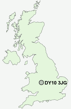
Postcode : DY10 3JG, Blakedown, Worcestershire
Belbroughton Road, Blakedown, Kidderminster.
DY10 3JG close to Blakedown, Churchill and Stakenbridge.
Classification
DY10 3JG : Urbanites / Ageing urban living / Self-sufficient retirement
Local Authority Wyre Forest
Primary Care Trust Worcestershire
Ward Wyre Forest Rural
Constituency Wyre Forest
Region West Midlands
Country England
Postcode Area DY : Dudley
DY10 Postcode Sectors
DY10 3JG Nearby Postcode Districts
B1 B10 B11 B12 B13 B14 B15 B16 B17 B18 B19 B2 B25 B26 B27 B28 B29 B3 B30 B31 B32 B33 B34 B38 B4 B45 B47 B48 B5 B60 B61 B62 B63 B64 B65 B66 B67 B68 B69 B7 B8 B9 B90 B91 B94 DY10 DY11 DY12 DY13 DY14 DY2 DY5 DY6 DY7 DY8 DY9 WR15
Stations near to DY10 3JG
Blakedown Rail StationHagley Rail Station about 1.81 miles away.
Stourbridge Junction Rail Station about 3.53 miles away.
Stourbridge Junction Rail Station about 3.54 miles away.
DY10 3JG Schools
Blakedown CofE Primary SchoolHagley Catholic High School
Haybridge High School and Sixth Form
UK Search
Antique Jewellery
including Antique Engagement Rings for sale from UK Antique specialists.