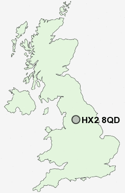
Postcode : HX2 8QD, Mixenden, Calderdale, West Yorkshire
Mixenden Road, Halifax.
HX2 8QD close to Mixenden, Moor End, Mount Tabor, Illingworth, Brookhouse and Upper Brockholes.
Classification
HX2 8QD : Hard-pressed living / Hard pressed ageing workers / Renting hard-pressed workers
Local Authority Calderdale
Primary Care Trust Calderdale
Ward Illingworth and Mixenden
Constituency Halifax
Region Yorkshire and The Humber
Country England
Postcode Area HX : Halifax
HX2 Postcode Sectors
HX2 9 Bradshaw, Causeway Foot, Holdsworth, Illingworth
HX2 8 Brookhouse, Mixenden, Moor End, Ogden, Ovenden
HX2 8QD Nearby Postcode Districts
BB10 BB11 BB12 BB4 BB9 BD1 BD10 BD11 BD12 BD13 BD14 BD15 BD16 BD17 BD18 BD19 BD2 BD22 BD3 BD4 BD5 BD6 BD7 BD8 BD9 HD2 HD3 HD6 HX1 HX2 HX3 HX4 HX5 HX6 HX7 LS1 LS10 LS11 LS12 LS13 LS18 LS2 LS27 LS28 LS3 LS4 LS5 LS6 LS7 LS8 LS9 OL13 OL14 WF12 WF13 WF14 WF15 WF16 WF17 WF2 WF3 WF5
Stations near to HX2 8QD
Sowerby Bridge Rail Station about 2.89 miles away.HX2 8QD Schools
Ash Green Community Primary SchoolAbbey Park Junior, Infant and Nursery School
Whitehill Community Primary School
Wainstalls Junior and Infant School
Ling Bob Junior, Infant and Nursery School
Mount Pellon Junior and Infant School
Halifax High at Wellesley Park
Rawson Junior and Infant School
UK Search
Antique Jewellery
including Antique Engagement Rings for sale from UK Antique specialists.