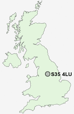
Postcode : S35 4LU, High Green, Sheffield, South Yorkshire
Wortley Road, High Green, Sheffield.
S35 4LU close to High Green, Potter Hill, Mortomley, Burncross, Charltonbrook and Warren.
Classification
S35 4LU : Urbanites / Urban professionals and families / White professionals
Local Authority Sheffield
Primary Care Trust Sheffield
Ward West Ecclesfield
Constituency Penistone and Stocksbridge
Region Yorkshire and The Humber
Country England
Postcode Area S : Sheffield
S35 Postcode Sectors
S35 8 Barnes Hall, Grenoside, Whitley, Wood Seats
S35 0 Brightholmlee, Foldrings, Middlewood, Onesacre, Oughtibridge
S35 7 Bromley, Crane Moor, Cundy Hos, Eastfield, Finkle Street
S35 2 Burncross, Chapeltown, Charltonbrook, Hood Hill, Lane End
S35 0 Brightholmlee, Foldrings, Middlewood, Onesacre, Oughtibridge
S35 7 Bromley, Crane Moor, Cundy Hos, Eastfield, Finkle Street
S35 2 Burncross, Chapeltown, Charltonbrook, Hood Hill, Lane End
S35 4LU Nearby Postcode Districts
DN1 DN12 DN2 DN4 DN5 S1 S10 S3 S35 S36 S4 S5 S6 S60 S61 S62 S63 S64 S65 S66 S70 S71 S73 S74 S75 S9
Stations near to S35 4LU
Chapeltown Rail Station about 1.28 miles away.S35 4LU Schools
High Green Primary SchoolGreengate Lane Primary School
Angram Bank Primary School
Lound Infant School
Lound Junior School
Windmill Hill Primary School
Coit Primary School
UK Search
Antique Furniture
1000s of pieces of Antique Furniture for sale from British antique dealers.