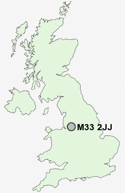
Postcode : M33 2JJ, Sale, Trafford, Greater Manchester
Worthington Road, Sale.
Classification
M33 2JJ : Hard-pressed living / Industrious communities / Industrious transitions
Local Authority Trafford
Primary Care Trust Trafford
Ward Sale Moor
Constituency Wythenshawe and Sale East
Region North West
Country England
Postcode Area M : Manchester
M33 Postcode Sectors
M33 2JJ Nearby Postcode Districts
M1 M11 M12 M13 M14 M15 M16 M17 M18 M19 M2 M20 M21 M22 M23 M27 M28 M29 M3 M30 M31 M32 M33 M34 M35 M4 M40 M41 M43 M44 M5 M6 M60 M7 M8 M90 OL5 OL6 OL7 SK1 SK12 SK13 SK14 SK15 SK16 SK2 SK22 SK23 SK3 SK4 SK5 SK6 SK7 SK8 SK9 WA1 WA12 WA13 WA14 WA15 WA2 WA3 WA4 WA5 WN4 WN7
Stations near to M33 2JJ
Trafford Park Rail Station about 2.45 miles away.Humphrey Park Rail Station about 2.56 miles away.
Navigation Road Rail Station about 2.64 miles away.
Manchester United FC Rail Station about 2.88 miles away.
M33 2JJ Schools
Worthington Primary SchoolLime Tree Primary School
Springfield Primary School
Brooklands Primary School
Park Road Primary School
Heyes Lane Primary School
Heyes Lane Infant School
UK Search
Antique Furniture
1000s of pieces of Antique Furniture for sale from British antique dealers.