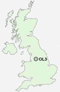
Postcode : OL3, Oldham, Greater Manchester
Postcodes in the OL3 sector. Covering areas such as Heights, Dale, Bleak Hey Nook, Denshaw, Uppermill, Slackcote, Diggle, Old Tame, Running Hill Head, Thurston Clough, Tunstead, New Delph, Pobgreen, Tame Water and Oldham in Greater Manchester.
Postcode Area OL : Oldham
OL3 Postcode Sectors
OL3 Nearby Postcode Districts
BL0 BL2 BL4 BL8 BL9 HD1 HD3 HD4 HD5 HD7 HD8 HD9 M1 M11 M12 M13 M15 M16 M17 M18 M2 M24 M25 M26 M27 M28 M3 M30 M34 M35 M4 M40 M43 M45 M5 M6 M60 M7 M8 M9 OL1 OL10 OL11 OL12 OL15 OL16 OL2 OL3 OL4 OL5 OL6 OL7 OL8 OL9 S36 SK15 SK16
Stations near to OL3
Greenfield Rail Station about 1 miles away.Mossley (Manchester) Rail Station about 2.94 miles away.
OL3 Schools
Saddleworth SchoolGreenfield Primary School
Diggle School
Delph Primary School
Greenfield St Mary's CofE School
Friezland Primary School
Bright Futures School for children with autism
UK Search
Antique Furniture
1000s of pieces of Antique Furniture for sale from British antique dealers.